Morocco is a country in North Africa with a rich cultural heritage, breathtaking landscapes, and an intriguing past. Understanding the geography of this diverse nation will help you enjoy it to the fullest. This is a helpful guide to comprehending Morocco’s primary topographical features, which include its mountains, deserts, and coastlines.
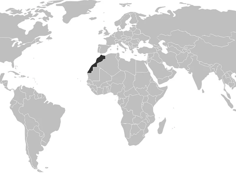
Morocco shares borders with the Mediterranean Sea to the north and the Atlantic Ocean to the west. To the east and southeast, it borders Algeria on land; to the south, it borders the disputed Western Sahara. Thanks to its location, Morocco is now at a crossroads of cultures and a major hub for trade between Europe, Africa, and the Middle East.
The Regions Along the Coast:
Morocco boasts an impressive 1,800 km (about 1,120 mi) of coastline, with each stretch offering something unique: Atlantic Coast: home to cities like Rabat and Casablanca. The largest city, Casablanca, is renowned for its vibrant economy and modern atmosphere. The capital, Rabat, blends modernity with historical charm.
Mediterranean Coast: With gorgeous beaches and a milder climate, towns like Tangier and Al Hoceima shine up north. For those who want to unwind and take in the breathtaking coastal scenery, this place is ideal.
Location of Morocco on the Map:

Moroccan Map of Google Maps:
The Mountains of Atlas:
From Morocco’s southwest border with Algeria to the Atlantic Ocean, the Atlas Mountains stretch. They are split up into three primary areas:
- High Atlas: This area is home to high peaks like 4,167-meter-tall Toubkal, which is the highest point in North Africa. It’s a popular place to go climbing and hiking. Along with traditional Berber villages, there are stunning views of the mountains.
- Middle Atlas: This region is more tranquil and less populated, and it is noted for its cedar forests and undulating hills. Cities with a cool climate and distinctive architecture, like Ifrane, sometimes referred to as “Little Switzerland,” provide a hint of European charm.
- The Anti-Atlas range, which lies in the south, is less well-known but has its own allure due to its unusual rock formations and arid surroundings. In addition, the stunning Dades and Todra Gorges are located there, as well as the Sahara Desert’s entrance.
The Desert of Sahara:
One of Morocco’s most recognizable landscapes is the Sahara Desert, which is located in southeast Morocco. Large sand dunes can be found here, close to Merzouga and Erg Chebbi. Camping under the stars and camel rides are ideal in this striking terrain.
Important Cities and Areas:
- Marrakech: Situated in the country’s center, Marrakech is well-known for its lively souks, historic medina, and diverse cultural scene. It acts as a point of entry for the desert and the Atlas Mountains.
- Fes: Situated in north-central Morocco, Fes is renowned for its historically significant buildings and well-preserved medieval architecture. Offering a comprehensive look into Moroccan history and culture, its ancient Médina is recognized as a UNESCO World Heritage site.
- Tangier: Situated on the northern coast, Tangier has long been a cross-cultural melting pot because of its closeness to Europe. Its advantageous location at the entrance to the Mediterranean contributes to its cultural diversity and richness.
Everyone can find something to enjoy in Morocco while visiting or joining a Morocco tour. Varied landscapes, which range from the Sahara Desert and the rough Atlas Mountains to the verdant coastal areas. The nation’s rich cultural heritage and stunning scenery are showcased in every region. You can make the most of your trip and fully appreciate what makes Morocco unique by being aware of its topography.


Comment (0)